


Mr. Philip D. Burden
P.O. Box 863,
Chalfont St. Giles, Bucks HP6 9HD,
UNITED KINGDOM
Tel: +44 (0) 1494 76 33 13
Email: enquiries@caburden.com
65 rare maps matched your search criteria.
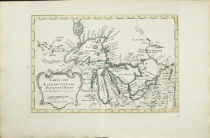
Paris, 1780
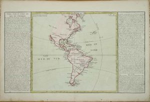
315 x 550 mm, including the side panels, early wash colour, very small worm hole in the centre, otherwise in good condition.
Stock number: 11150
$ 175
John Melish, Philadelphia, 6th day of June 1816
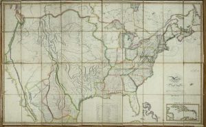
MANIFEST DESTINY, FIRST EDITION, FOURTH ISSUE. 885 x 1440 mm., copper engraved map on six sheets, laid on contemporary linen, edged in silk, cut and dissected, early outline colour, marbled endpapers, in good condition.
Stock number: 11012
$ 69,500
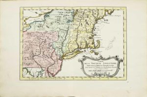
Cadell & Davies & Longman, Hurst, Rees, Orme & Brown, London, 1809-[15]
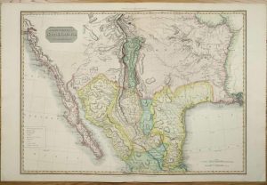
515 x 705 mm., lovely early wash colour, in good condition.
Stock number: 10940
$ 1,350
Sold by Tho:Bassett in Fleetstreet and Richard Chiswell in St. Pauls Church Yard, London, 1676
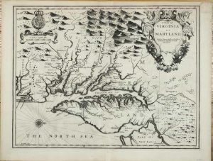
380 x 500 mm., with a small upper right corner margin repair, otherwise in good condition.
Stock number: 10915
$ 4,500
Sold by Tho:Bassett in Fleetstreet and Richard Chiswell in St. Pauls Church Yard, London, 1676
380 x 505 mm., in good condition.
Stock number: 10914
$ 5,500
Ernest van Harrevelt; Daniel Jean Changuion, Amsterdam, 1773
200 x 290 mm., in very nice full early wash colour, good condition.
Stock number: 10803
$ 450
November 1780
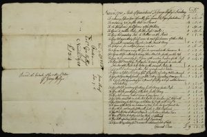
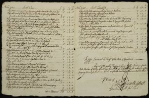
215 x 165 mm., uncut manuscript four page ledger, in good condition.
Stock number: 10819
$ 1,950
Ernest van Harrevelt; Daniel Jean Changuion, Amsterdam, 1773
190 x 290 mm., in very nice early outline colour, good condition.
Stock number: 10801
$ 595
Ernest van Harrevelt; Daniel Jean Changuion, Amsterdam, 1773
210 x 295 mm., in very nice full early wash colour, good condition.
Stock number: 10802
$ 350
George Catlin. Egyptian Hall, Piccadilly [but Chatto & Windus], London, [1875]
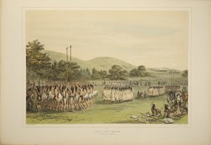
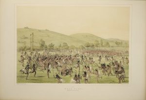
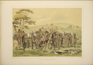
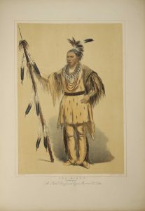
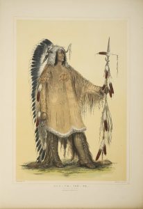
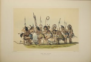
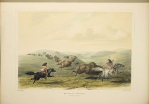
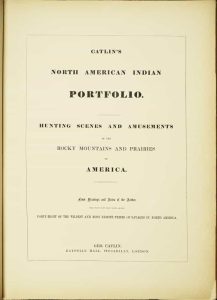
THE RARE 31 PLATE ISSUE. Folio (595 x 430 mm.), contemporary half straight-grained blue morocco by Zaehnsdorf, uncut, blue cloth boards, gilt ruled, spine with ornate gilt raised bands, compartments with ornate central gilt feature and gilt titles, gilt top, marbled endpapers. With title page, Contents and 31 hand coloured lithographic plates (25 numbered and 6 unnumbered), each with blank interleaf, a few margins lightly stained, lower corner of title page chipped, 5 plates with waterstain in the margins effecting the image of only one - 'Attacking the Grizzly Bear', otherwise in good condition.
Stock number: 10495
$ 125,000
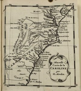
Printed by T. Milbourn, and sold by J. Williams Junior, in Cross-Keys-Court, in Little-Brittain, London, 1672
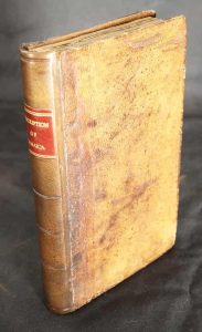
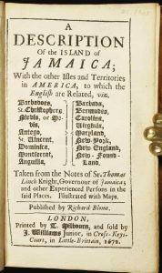
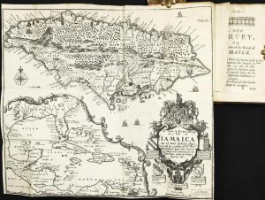
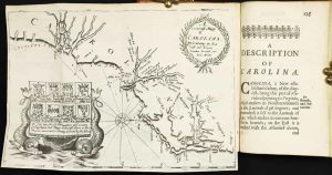
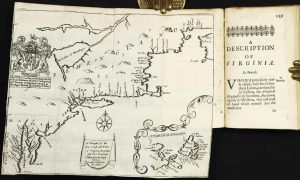
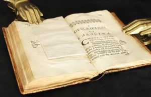
INCLUDING THE SECOND MAP OF CAROLINA. Octavo (150 x 95 mm.), full contemporary calf, blind panelled, rebacked with blind ruled compartments, red calf gilt title label, original endpapers. With typographic title page, dedication to Charles II, Preface, pp. (8), 192, with three folding maps, in excellent condition.
Stock number: 10277
$ 26,500
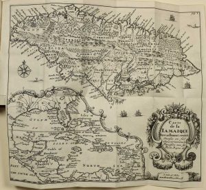
Paris, 1612
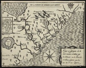
AN EXCEEDINGLY RARE MAP. 160 x 210 mm., with tight margins as always, lower margin just into the neatline, otherwise a good example of an extremely rare map.
Stock number: 10481
$ 22,500
Florence, c.1665
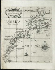
ONE OF ONLY TWO KNOWN EXAMPLES. 225 x 195 mm., small tear lower left corner repaired, otherwise in good condition.
Stock number: 10391
$ 65,000
A Paris dans l'!sle sur Ie Quay de l'Orloge a la Sphere Royale avec Prive. Du Roy 1715, Paris, 1715
EXTREMELY RARE FIRST STATE OF NICOLAS DE FER'S LANDMARK MAP IN FULL CONTEMPORARY WASH COLOUR. 465 x 640 mm., in full early wash colour, faint water stain lower centrefold, otherwise in excellent condition.
Stock number: 9768
$ 49,500
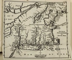
Paris, 1772
320 x 375 mm., in good condition.
Stock number: 5192
£ 150
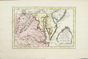
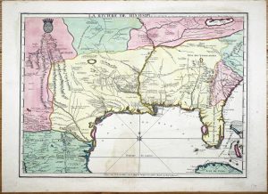
Paris, 1803
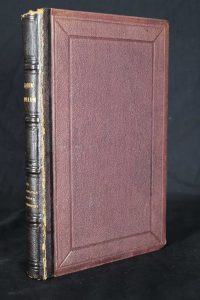
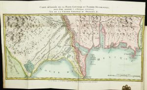
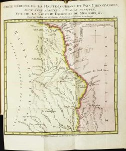
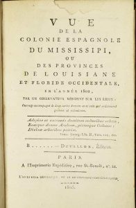
A FIRST HAND ACCOUNT OF LOUISIANA. Octavo, nineteenth century quarter calf, panelled cloth boards, gilt spine, with marbled endpapers. XX, 318, 5, (4) pp. Slight loss of paper to the title page. With two folding maps in full contemporary wash colour in excellent condition.
Stock number: 1703
$ 2,950
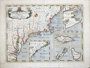
London, 1765
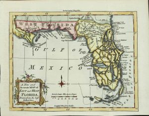
180 x 220 mm., in recent wash colour, good condition.
Stock number: 3993
$ 450
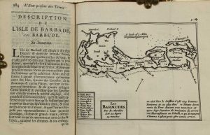
London, 1764
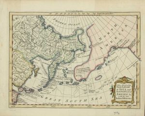
170 x 230 mm., modern wash colour, in fine condition.
Stock number: 3996
$ 225
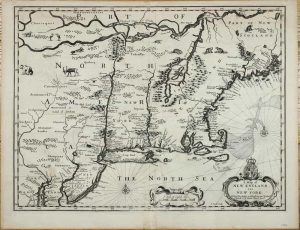
Chez Abraham Wolfgang, pres la Bourse, Amsterdam, 1688
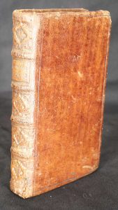
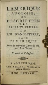
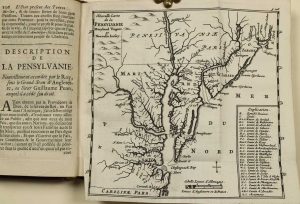
WITH A PREVIOUSLY UNRECORDED FIRST STATE OF THE MAP OF NEW ENGLAND. Duodecimo (150 x 85 mm.), full contemporary calf, blind panelled, with ribbed spine, very ornate gilt decoration to compartments, gilt title, gilt slightly worn. With typographic title page, pp. [4], 331, [1], p. 236 erroneously numbered 136, with 7 folding maps, otherwise in excellent condition.
Stock number: 9894
$ 4,950
London, 1700-[c.05]
350 x 480 mm., in recent wash colour and good condition.
Stock number: 7988
$ 2,950