


Mr. Philip D. Burden
P.O. Box 863,
Chalfont St. Giles, Bucks HP6 9HD,
UNITED KINGDOM
Tel: +44 (0) 1494 76 33 13
Email: enquiries@caburden.com
45 rare maps matched your search criteria.
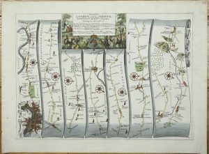
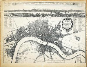
London, 1612
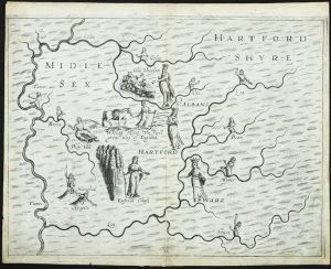
FIRST STATE. 250 x 335 mm., lower centrefold split professionally repaired, light mark in lower right corner, otherwise in good condition.
Stock number: 11766
£ 325
Vanity Fair, London, 1879
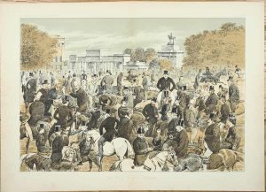
THE FIRST DOUBLE PAGE LITHOGRAPH PUBLISHED IN VANITY FAIR. 340 x 460 mm., double page lithograph, in very good condition.
Stock number: 11282
£ 150
Vanity Fair, London, 1878
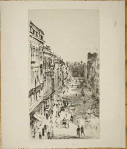
300 x 160 mm., trimmed top and bottom, otherwise in good condition.
Stock number: 11283
£ 50
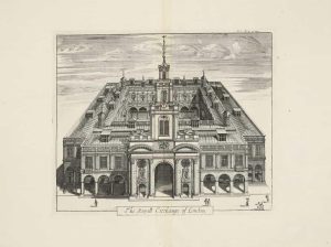
John Garrett at the South Entrance of the Royall Exchange, London, 1644-[76]
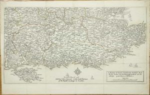
280 x 505 mm., early outline colour, folds as issued, small area of loss along fold, repaired, otherwise in good condition.
Stock number: 11264
£ 295
London, 1675
335 x 470 mm., later wash colour, very small paper flaw in second strip, otherwise in good condition.
Stock number: 11265
£ 425
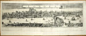
Sould by John Overton at the White Horse at the corner of the little old Baly neere the fountaine tavern without Newgate, London, 1666-[68]
PANORAMAS OF LONDON BEFORE AND AFTER THE FIRE. 225 x 675 mm., two sheets joined, with one small tear at right side fold, laid onto paper, otherwise in good condition.
Stock number: 10470
£ 8,500
John Bowles Cornhill & Carington Bowles in St. Pauls Church Yard & Robt. Sayer, in Fleet Street, London, 1751-[c.67]
525 x 725 mm., early outline colour, small tear in upper margin repaired, not effecting the image, light fraying to margin lower right, otherwise in good condition.
Stock number: 10974
£ 750
Amsterdam, 1645-[48]
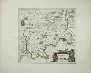
390 x 405 mm., With early outline colour, in double-glazed frame, in good condition.
Stock number: 10979
£ 495
London, 1803
70 x 70 mm., with text below, in fine full early wash colour.
Stock number: 10817
£ 95
London, 1756
370 x 470 mm., with folds as issued, in good condition.
Stock number: 10901
£ 225
London, 1720
355 x 295 mm., in good condition.
Stock number: 10896
£ 150
London, 1695
360 x 420 mm., trimmed tight upper side borders, in good condition.
Stock number: 10853
£ 110
No. 81 Fleet Street, London. (From 38 Ludgate Street), London, 1830-[40]
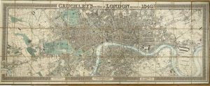
UNRECORDED ISSUE. 525 x 1380 mm., early outline and wash colour, dissected and laid on linen, green cloth ends, one small split, otherwise in good condition.
Stock number: 10850
£ 2,500
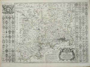
Nuremberg, 1741
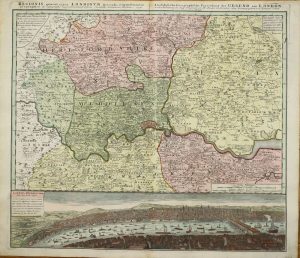
510 x 570 mm., full early wash colour, in good condition.
Stock number: 10686
£ 650
London, 1720
250 x 290 mm., very small tear upper margin repaired, otherwise in good condition.
Stock number: 10783
£ 150
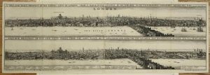
London, 1666
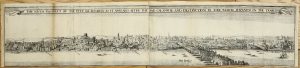
A TOTALLY UNRECORDED PANORAMA OF THE AFTERMATH OF THE GREAT FIRE OF LONDON. 140 x 665 mm., two sheets joined, trimmed from a lower panorama, small paper hole on right side, otherwise in good condition.
Stock number: 10469
£ 19,500
Sold by Robert Green at ye Rose and Crown, in Budg-Row. And by Robert Morden. at ye Atlas in Cornhill, London, 1675
FIRST STATE. 435 x 585 mm., etching, light toning to the paper, otherwise in very good condition.
Stock number: 10468
£ 17,500
London, c.1690
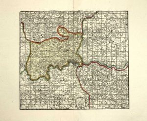
A VERY EARLY ENVIRONS MAP. 260 x 290 mm., in early wash colour, with large margins, in very good condition.
Stock number: 9990
£ 1,750
Phil. Lea at ye Atlas & Hercules in Cheapside, London, c.1690
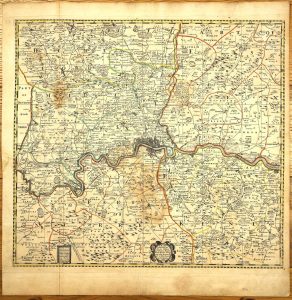
515 x 560 mm., early outline colour, with minor water stain, printed on thick paper, with fold as issued, otherwise in good condition.
Stock number: 9734
£ 4,500
Battista Hacque, Vienna, 1674
290 x 890 mm., two sheet copper plate engraving joined, in excellent condition.
Stock number: 9733
£ 3,950