Mr. Philip D. Burden
P.O. Box 863,
Chalfont St. Giles, Bucks HP6 9HD,
UNITED KINGDOM
Tel: +44 (0) 1494 76 33 13
Email: enquiries@caburden.com
34 rare maps matched your search criteria.
Paris, 1830
315 x 415 mm., lithographic print in later wash colour, in good condition.
Stock number: 8620
£ 150
G. G. & J. Robinson, London, 1799
![Plan de l'Ile de Paque [on sheet with] Plan de la Baie de Cook Situee a la Cote Occid. l'Ile de Paque [and] Vues de l'Ile de Paque](https://www.caburdenraremaps.com/wp-content/uploads/2024/05/8108-300x240.jpg)
380 x 500 mm., slight discolouration along the centrefold otherwise in good condition.
Stock number: 8108
£ 150
Paris, 1797
![Plan de l'Ile de Paque [on sheet with] Plan de la Baie de Cook Situee a la Cote Occid. l'Ile de Paque [and] Vues de l'Ile de Paque](https://www.caburdenraremaps.com/wp-content/uploads/2025/03/8107-300x204.jpg)
500 x 680 mm., with recent wash colour, in very good condition on lovely quality large margined paper.
Stock number: 8107
£ 375
Amsterdam, c.1750
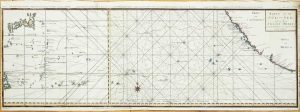
870 x 300 mm., in two sheets joined, with recent outline colour, folds as issued in the book but here ironed out, with minor paper crease and binders tear repaired, otherwise in good condition.
Stock number: 7494
£ 275
Paris, 1683
170 x 105 mm., full recent wash colour, in good condition.
Stock number: 7423
£ 110
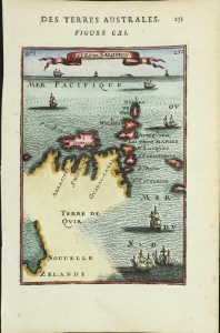
Padua, 1789
365 x 250 mm., in excellent condition, a very fresh example with a superb large watermark.
Stock number: 6286
£ 650
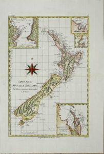
Saillant et Nyon & Panckouke, Paris, 1774
480 x 380 mm., with recent wash colour, old folds as issued in the volume, with a pin sized hole as might be expected to double fold, strong watermark, in excellent condition.
Stock number: 6287
£ 1,850
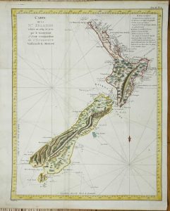
Saillant et Nyon & Panckouke, Paris, 1774
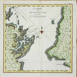
270 x 275 mm., old folds as issued in the book, some minor spotting, otherwise in very good condition.
Stock number: 6288
£ 260
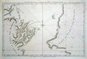
Saillant et Nyon & Panckouke, Paris, 1774
![Riviere Tamise et Baye Mercure a la Nle. Zelande, Baye des Isles dans la Nle. Zelande [and] Baye de Tolaga dans la Nle. Zelande](https://www.caburdenraremaps.com/wp-content/uploads/2024/05/6289-300x213.jpg)
275 x 430 mm., old folds as issued in the book, in very good condition.
Stock number: 6289
£ 260
Paris, c.1780
235 x 345 mm., in good condition.
Stock number: 5748
£ 125
London, 1784
225 x 335 mm., lower left corner trimmed not affecting the image otherwise in good condition.
Stock number: 5758
£ 150