


Mr. Philip D. Burden
P.O. Box 863,
Chalfont St. Giles, Bucks HP6 9HD,
UNITED KINGDOM
Tel: +44 (0) 1494 76 33 13
Email: enquiries@caburden.com
94 map-related books matched your search criteria.
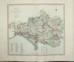
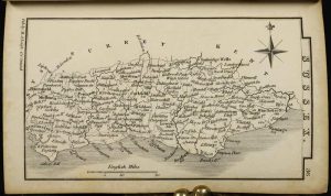
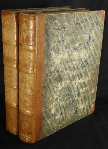
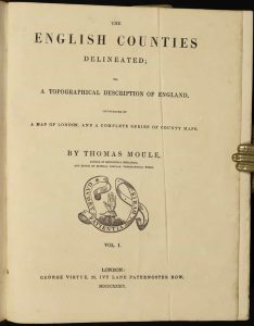
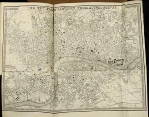
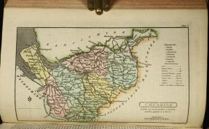
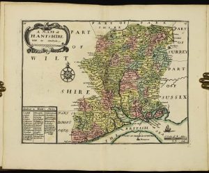
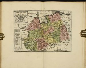
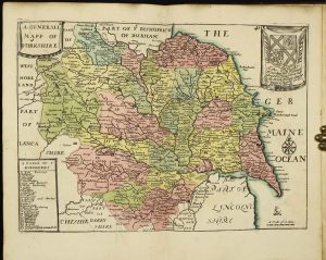
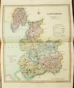
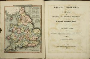
George Virtue, 26, Ivy Lane Paternoster Row, London, 1837
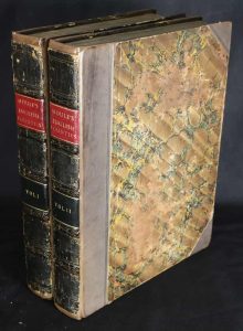
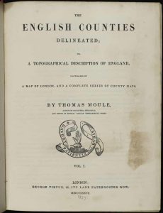
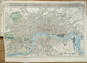
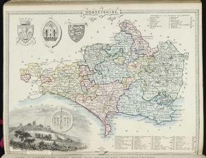
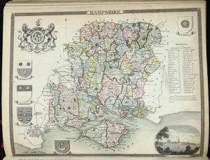
FIRST EDITION IN EARLY WASH COLOUR. Quarto, 2 volumes (275 x 210 mm. each), contemporary half calf, marbled paper boards, gilt ruled, ornate gilt ribbed spines, calf gilt title labels, marbled endpapers. With engraved frontispiece of King William IV bearing title, further engraved title page with vignette of Greenwich Hospital, typographic title page, pp. xxiv, 484; typographic title, pp. (2), 582, with 57 maps on 60 plates, comprising 2 general maps (1 folding, the other in 4 sheets), 42 maps of the English counties, 3 islands, 3 plans of London (2 folding), 7 further plans of towns and environs, 1 further engraving of the 'Principal Hills', all in EARLY WASH COLOUR, large folding London with repaired binders tear, Metropolitan Boroughs with minor tear, otherwise a good example.
Stock number: 9563
£ 1,950
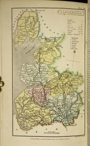
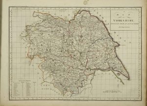
Printed for C. Smith, Mapseller, No. 172 (Corner of Surrey Street) Strand, London, 1804-[08]
Folio (540 x 360 mm.), contemporary half calf, ornate gilt ruled, marbled paper boards, spine with gilt ruled raised bands, gilt calf title label, worn. With engraved title page, engraved Contents and Explanation, and 46 double page maps all in early wash colour including one general map, 40 of the counties of England (Yorkshire made up of 4 sheets) and Wales in two sheets, large Index to place names and a 2-page list of subscribers, pp. 54, in good condition.
Stock number: 9529
£ 1,750
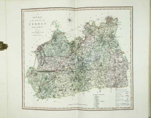
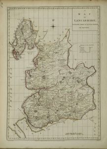
Robert Laurie and James Whittle, No. 53, Fleet-Street, London, 1807
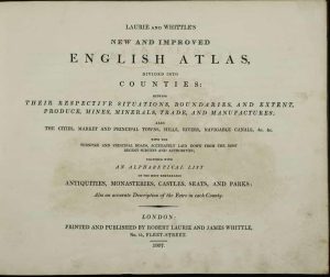
Oblong quarto (230 x 295 mm.), later half red calf to style, preserving original paper boards with ornate printed panels, spine with gilt ruled compartments, each with central gilt floral design, gilt title. With finely engraved frontispiece title, typographic title, Advertisement, Contents, engraved Explanation in early colour and 48 engraved maps (West Riding in 2 sheets) all in fine early outline colour with wash borders, each accompanied by a leaf of descriptive text, some surface dirt to first general map, South Wales with light paper folds, otherwise in good condition.
Stock number: 9526
£ 995
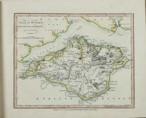
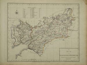
T. Kitchin, No. 59, Holborn Hill. & Andrew Dury, Duke's Court, St. Martins Lane, London, 1777
Quarto (270 x 220 mm.), recent half calf, marbled paper boards, blind ruled, spine with raised bands, gilt ruled compartments, gilt titles. With engraved title page, typographic contents list and 45 engraved double page maps, all in early outline colour, browning to contents list, a few minor splits in the lower centrefolds, otherwise in good condition.
Stock number: 9505
£ 2,950
London, 1837
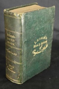
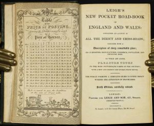
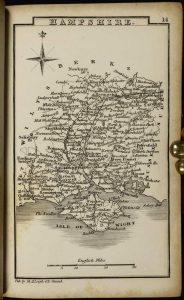
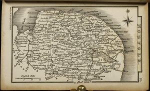
Sextodecimo (145 x 90 mm.), full contemporary green morocco, with gilt title to upper board, spine with gilt ruled compartments and titles, light wear. Frontispiece 'Table of the Price of Posting', letterpress title to 'Road-Book', 'Preface to the first edition', 'Preface to the fifth and sixth edition', engraved frontispiece title to 'New-Atlas', pp. vi, 511, (1), 4, with 55 county maps, folding general map of England and Wales in early outline and wash colour a little worn, otherwise in good condition.
Stock number: 9558
£ 125
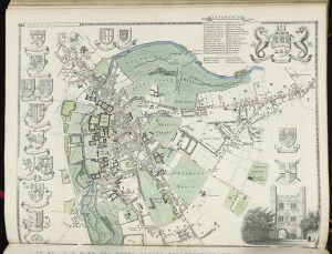
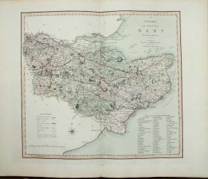
George Virtue, 26, Ivy Lane Paternoster Row, London, 1839-38
Quarto (275 x 220 mm. each), two volumes, contemporary half calf, marbled paper boards, spine with ornate gilt raised bands, each compartment with ornate gilt decoration, gilt titles. With engraved frontispiece in the second state with Queen Victoria, engraved title 'Englands Topographer', typographic title page dated 1839, pp. xxvi, 484; title with vignette of Greenwich Hospital, typographic title page to second volume dated 1838, pp. (2), 582. Complete with 57 maps on 60 plates, comprising 2 general maps (1 folding, the other in 4 sheets), 42 maps of the English counties, 3 islands, 3 plans of London (2 folding, Boroughs wrinkled), 7 further plans of towns and environs, 1 further engraving of the 'Principal Hills', engraved frontispiece of Canterbury Cathedral bound with the Kent section, Monmouth lacking.
Stock number: 9544
£ 950
Richard Phillips, Bridge-Street, Blackfriars, London, 1808
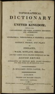
Octavo (215 x 135 mm.), full tree calf, rebacked with gilt ruled embossed raised bands, gilt title to red calf label, marbled endpaper. With engraved general map of the British Isles, typographic title page, Introduction, List of the Maps with advert on the verso pp. xiv, (2), followed by the Dictionary unpaginated, B1-3X2, with 46 maps, one unnumbered double page general map, 40 maps of the English counties, 2 maps of Scotland, Wales and 2 maps comprising Ireland, Yorkshire and general maps all folding, all in early wash colour, in good condition.
Stock number: 9528
£ 195
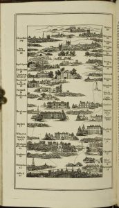
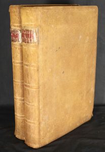
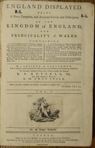
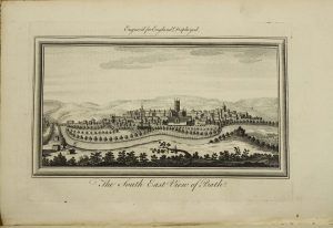
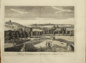
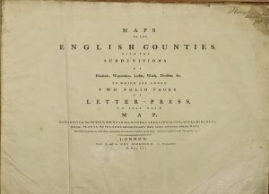
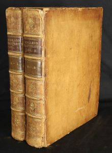
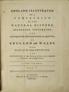
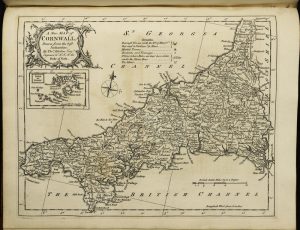
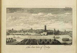
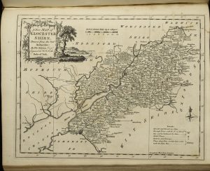
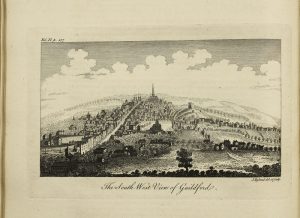
Printed for R. and J. Dodsley, in Pall-mall, London, 1763[64]
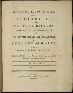
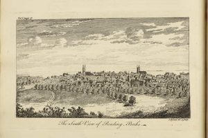

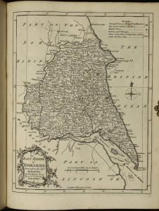
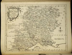
Quarto, two volumes (295 x 240 mm each.), full contemporary calf, rebacked ribbed spine, ornate gilt ruled compartments with central ornate gilt feature, gilt calf title and volume labels affixed, marbled endpapers. With typographic title page, Preface, Contents, Introduction, pp. (8), xiii, blank, 426; typographic title page, Contents, pp. (4), 490, with two general folding maps, 52 engraved county maps, all by Thomas Kitchin, 39 engraved town views and numerous other engravings set in the text, complete with blank endpapers, some offsetting from maps to text as usual, both folding maps with binders tears as usual, repaired, otherwise a good example.
Stock number: 9501
£ 1,350
Thomas Taylor at ye Golden Lyon in Fleetstreet, London, c.1716
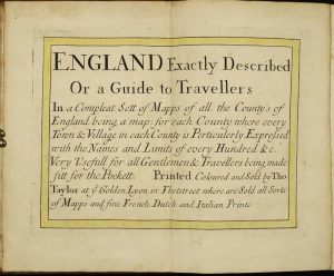
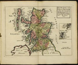
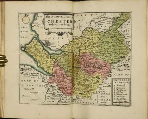
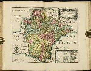
FULL EARLY WASH COLOUR. Quarto (240 x 160 mm.), full early calf, ornate gilt panelled boards, rebacked spine with gilt ruled raised bands, red calf gilt title. With engraved double page title, 41 double page maps numbered to 41 (Scotland unnumbered, Cumberland and Westmoreland combined '8 & 9'). England and Scotland both first state, as called for, all in fabulous early wash colour, in good condition.
Stock number: 9491
£ 3,950
Printed by C. Whittingham, Dean Street, Fetter Lane and Sold by H D. Symonds, Paternoster-Row, London, 1802
Octavo (215 x 125 mm.), contemporary half calf, marbled paper boards, ornate gilt panelling, spine with very ornate gilt embossed decoration and title, marbled endpapers. With typographic frontispiece, pp. iv, 66, with 18 aquatint plates of the roads and 13 further aquatints, in good condition.
Stock number: 10859
£ 850
Amsterdam, c.1700
![[Tomus III. Engeland, Schottland, Irland]](https://www.caburdenraremaps.com/wp-content/uploads/2023/05/10726a-184x300.jpg)
![[Tomus III. Engeland, Schottland, Irland]](https://www.caburdenraremaps.com/wp-content/uploads/2023/05/10726b-252x300.jpg)
![[Tomus III. Engeland, Schottland, Irland]](https://www.caburdenraremaps.com/wp-content/uploads/2023/05/10726c-259x300.jpg)
![[Tomus III. Engeland, Schottland, Irland]](https://www.caburdenraremaps.com/wp-content/uploads/2023/05/10726d-300x215.jpg)
![[Tomus III. Engeland, Schottland, Irland]](https://www.caburdenraremaps.com/wp-content/uploads/2023/05/10726e-300x234.jpg)
![[Tomus III. Engeland, Schottland, Irland]](https://www.caburdenraremaps.com/wp-content/uploads/2023/05/10726f-300x233.jpg)
![[Tomus III. Engeland, Schottland, Irland]](https://www.caburdenraremaps.com/wp-content/uploads/2023/05/10726g-239x300.jpg)
![[Tomus III. Engeland, Schottland, Irland]](https://www.caburdenraremaps.com/wp-content/uploads/2023/05/10726h-300x226.jpg)
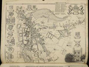
MAGNIFICENT FULL EARLY WASH COLOUR. Folio (510 x 325 mm.), contemporary half calf, paper boards with armorial shaped paper pasted to upper board containing in manuscript the title above, spine with raised bands and worn. With contemporary manuscript index inside front cover and 64 maps all in early wash colour, consisting of 10 general maps, 9 Scottish counties, 4 regional Irish, 37 of the English counties and 4 Welsh, 4 maps with Japanese tissue repairs to verso, some browning of colour, otherwise in good condition.
Stock number: 10726
£ 17,500
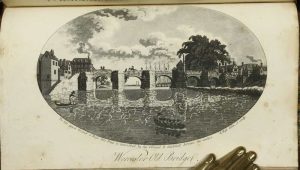
Darton and Clark, 58 Holborn Hill, London, c.1844
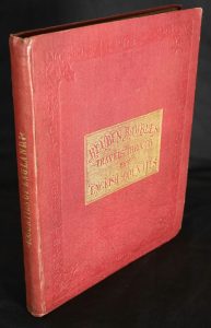
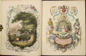
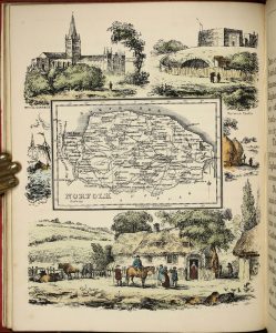
Quarto (210 x 170 mm.), full contemporary red cloth, ornate blind ruling to boards, gilt embossed title to upper board, gilt title to spine. With pictorial frontispiece and title, further letterpress title, Preface and 40 early wash coloured lithographic plates, some light offsetting as usual, otherwise a good example.
Stock number: 10755
£ 1,650
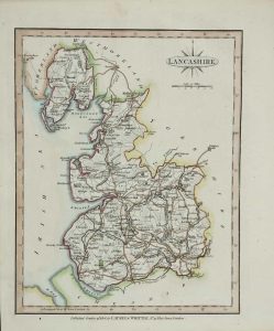
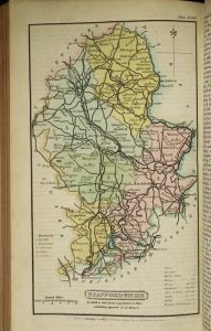
Henry Teesdale & Co. 302, Holborn, London, 1831-[32]
Large quarto (365 x 255 mm.), full contemporary diced calf, ornate blind and gilt panelled, ribbed spine with ornate gilt raised bands, gilt title and gilt edged, marbled endpapers. With double page engraved title corrected to 1831, three folding general maps backed on contemporary cloth, 2 double page maps of North & South Wales, 43 county maps, and a folding map showing parliamentary representation in England & Wales for June 1832 backed on publisher's linen, all in early wash colour, Somerset with centrefold split, otherwise a good example.
Stock number: 10753
£ 1,250
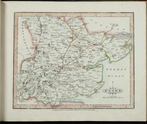
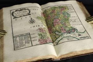
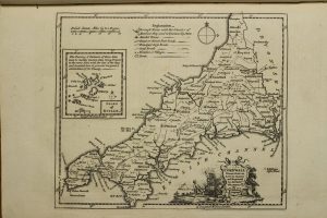
John Cary, Engraver, Map and Print-seller, the corner of Arundel Street, Strand, London, 1787-[89]
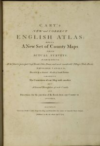
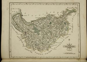
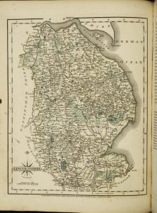
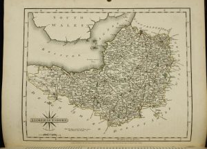
FIRST EDITION, FIRST ISSUE. Quarto (320 x 250 mm.), recent half calf, cloth boards, blind ruled, spine with blind panelled compartments, red calf gilt title, later endpapers. With engraved title page, engraved dedication, Advertisement (first state), typographic Contents (first state), map of South Britain, and 43 county maps on 44 plates (West Riding being on two plates), and both North and South Wales, 47 maps in total, each accompanied by a leaf of descriptive text, all in early outline colour with main routes coloured brown with wash to wooded areas, pp. 6 'Directions for the Junctions of the Roads of England and Wales through all the Counties', pp. 4 'Market and Borough Towns in England and Wales', pp. 7 'List of the Principal Post and Sub-Post Towns in England and Wales', pp. 6 List of Subscribers (first state), margin repair to text leaf of Essex, otherwise in good condition.
Stock number: 10741
£ 850
Lackington, Allen & Co. Temple of the Muses Finsbury Square, London, 1806
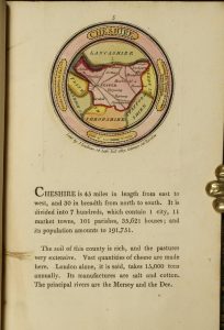
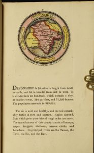
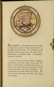
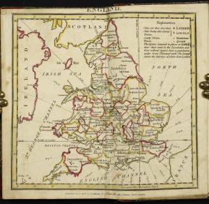
Octavo (185 x 110 mm.), contemporary half red calf, marbled paper boards, gilt ruled, with original paper title label affixed to the upper board, spine with gilt ruled compartments, paper label with manuscript title affixed, with original silk page marker. With ornate engraved title, Preface dated March 1803, half title 'England', 42 circular maps of the English counties, half title 'Wales', 12 maps of the Welsh counties, all in FULL EARLY WASH COLOUR, each with typographic text below, a double page map of England and Wales in early outline colour, Index leaf, some light show through on a few maps to the versos, otherwise in good condition.
Stock number: 10746
£ 3,950
London, 1769-70
Folio, two volumes in one (340 x 225 mm.), full contemporary sheepskin, ornate blind panelled boards, spine with raised bands, red calf gilt title labels, corners with light wear. With engraved frontispiece, typographic title page including engraved vignette, pp. viii, 392 with 26 maps; volume 2 with typographic title page, pp. 314, (4) with 27 maps, with circa 80 copper plate views throughout, Cheshire with minor margin repair, contemporary manuscript index to front free endpaper of first volume, otherwise in good condition.
Stock number: 10739
£ 1,250
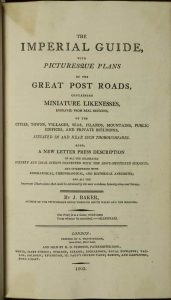
Printed by and for John Harrison No. 115, Newgate-Street, London, 1791
FIRST EDITION. Oblong folio (410 x 530 mm.), contemporary half calf, marbled paper boards, expertly rejointed preserving the original spine, with gilt title, later endpapers but preserving original front endpapers with extensive manuscript notations about bricks. With typographic title page upper and lower edges strengthened, pp. (2), viii, with 38 side bound engraved maps, each in early outline colour, facing each other in pairs with interleaved descriptive text facing each map, stained upper right corner on first few leaves, light paper wrinkles first and last leaves, otherwise in good condition.
Stock number: 10742
£ 1,500
Baldwin, Cradock and Joy, London, 1816
Quarto (310 x 240 mm.), contemporary half calf, marbled paper boards, raised bands with gilt titles to spine. With typographic title page, pp. 18, with 2 general maps of England and Wales and 56 further maps of the counties all in early outline colour, each interleaved with descriptive text, in good condition.
Stock number: 10749
£ 1,250
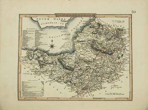
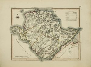
Printed for R. and J. Dodsley, in Pall-mall, London, 1763[64]
Quarto, two volumes (285 x 225 mm. each), full contemporary calf, ribbed spines gilt ruled compartments with decorative gilt central floral features, gilt calf title labels. With typographic title page, Preface, Contents, Introduction, pp. (8), xiii, blank, 426; typographic title page, Contents, pp. (4), 490, with two general folding maps, 52 engraved county maps, all by Thomas Kitchin, 39 engraved town views and numerous other engravings set in the text, complete with blank endpapers, some offsetting from maps to text second folding map wrinkled, otherwise a good example.
Stock number: 10733
£ 1,500
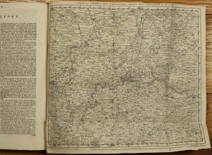
Printed and sold by Thomas Bowles, fourth edition, London, 1753
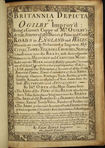
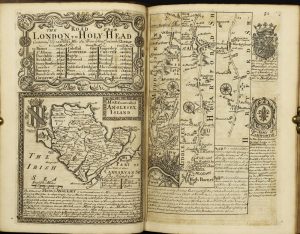
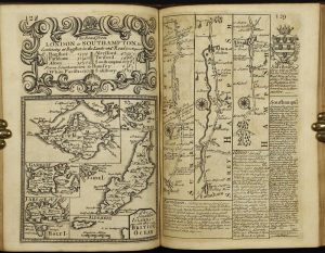
RARE EDITION. Octavo (195 x 140 mm.), full calf, spine with blind ruled bands. With engraved title page, eight typographic preliminary pages and 273 engraved plates of road strips, county maps and descriptive text, pp. (2), 5, (3), 273, (1), good margins throughout, with light toning as is often the case, final original blank endpaper week at the edges, otherwise in good condition.
Stock number: 10732
£ 1,100