


Mr. Philip D. Burden
P.O. Box 863,
Chalfont St. Giles, Bucks HP6 9HD,
UNITED KINGDOM
Tel: +44 (0) 1494 76 33 13
Email: enquiries@caburden.com
94 map-related books matched your search criteria.
Printed by C. Whittingham, Dean Street, Fetter Lane and Sold by H D. Symonds, Paternoster-Row, London, 1802
Octavo (225 x 140 mm.), old half vellum, contemporary paper boards, later endpapers, uncut. With typographic frontispiece, pp. iv, 66, with 14 aquatint plates of the roads with early wash coloured borders and 5 further aquatints, in good condition.
Stock number: 10218
£ 850
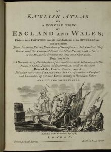
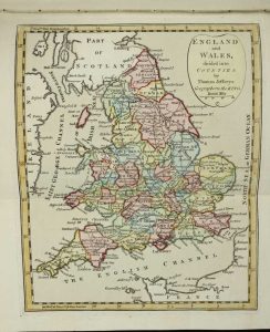
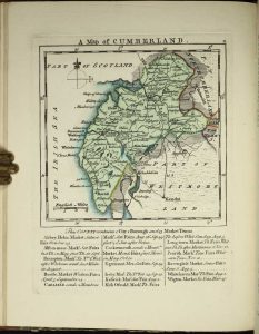
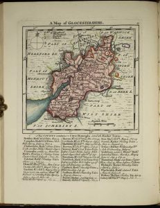
Lackington, Allen & Co. Temple of the Muses Finsbury Square, London, 1806
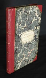
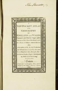
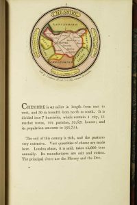
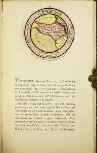
Octavo (185 x 115 mm.), contemporary marbled paper boards, rebacked in red morocco, gilt ruled, with original paper title label affixed to the upper board, spine with gilt ruled bands. With ornate engraved title, Preface dated March 1803, half title 'England', 42 circular maps of the English counties, half title 'Wales', 12 maps of the Welsh counties, all in FULL EARLY WASH COLOUR, each with typographic text below, a double page map of England and Wales in early outline colour, blank leaf with manuscript table, Index leaf, some light show through on a few maps to the versos, some offsetting to final map, otherwise in good condition.
Stock number: 10221
£ 3,250
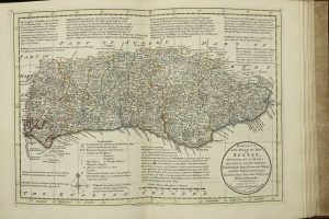
Printed for C. Smith, Mapseller, No. 172 (Corner of Surrey Street) Strand, London, 1804
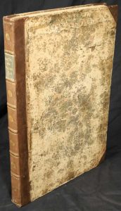
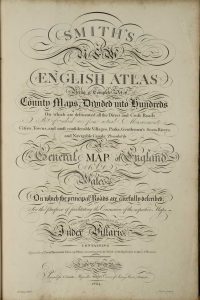
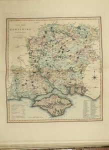
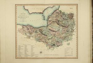
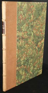
Folio (545 x 365 mm.), contemporary half calf, marbled paper boards, rebacked with raised bands, ornate gilt ruled compartments each with central gilt feature, gilt date and green calf gilt title label, light wear. With engraved title page and contemporary tissue, engraved Contents and Explanation, and 46 double page maps all in early wash colour including one general map, 40 of the counties of England (Yorkshire made up of 4 sheets) and Wales in two sheets, (southern half with centrefold split), large Index to place names and a 2-page list of subscribers, pp. 54, otherwise in good condition.
Stock number: 10222
£ 2,500
London, 1767-68
VERY RARE FIRST EDITION, FIRST ISSUE. Folio (370 x 240 mm.), modern quarter calf by Temple Bindery, marbled paper boards, gilt ruled, gilt ruled ribbed spine with red calf gilt title label. With engraved title page frayed and laid down, pp. 4 'Subscribers Names' and 45 copper engraved maps in early outline colour, with two further maps of new Jersey and France inserted at the end.
Stock number: 10180
£ 6,500
Carington Bowles at his Map and Print Warehouse, No. 69, in St. Paul's Church Yard, London, 1785
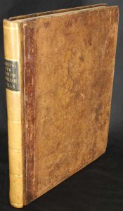
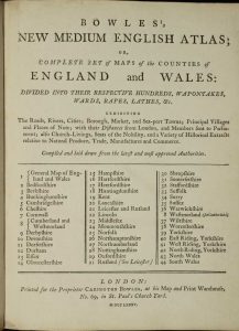
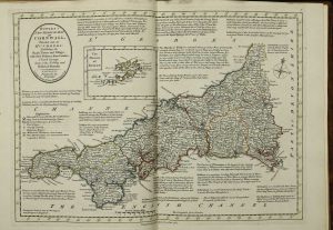
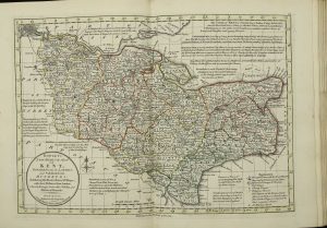
Quarto (260 x 210 mm.), full contemporary quarter mottled calf, gilt ruled, rebacked with gilt ruled compartments, original calf gilt title label preserved. With typographic title and 44 copper engraved maps in early outline colour and yellow wash border, the general map in early wash colour, lower right corner of final map with some minor dirt, otherwise in good condition.
Stock number: 10182
£ 3,750
Printed for, and Sold by the Author, and the Booksellers, London, 1 January 1777-[83]
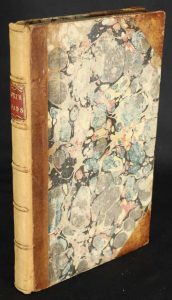
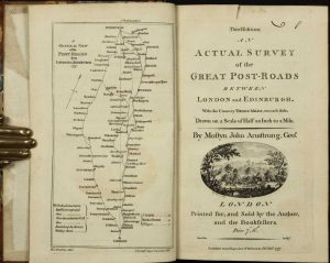
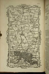
Octavo (195 x 125 mm.), contemporary half calf, marbled paper boards, rebacked with raised bands, with gilt red calf title. With general plan, engraved title with contemporary ownership inscription cut upper right, pp. 7, (1), 44 and 44 maps, with contemporary manuscript pagination, otherwise in good condition.
Stock number: 10189
£ 350
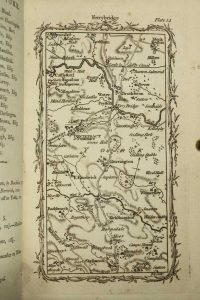
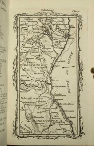
H. Moll, T. Bowles, C. Rivington & J. Bowles, London, 1724-[c.32]
Folio (350 x 225 mm.), full contemporary calf, boards with ornate blind panelling, rebacked with ribbed spine and gilt ruled compartments, with red calf gilt title label. Typographic title printed in red and black, with 50 engraved maps, the two general maps folding on evenly toned paper, a few engraved illustrations, pp. (2), xi, (1), 344, x. Kent with light wear at the outer margin, last few leaves with old water stain in the lower gutter, otherwise in good condition.
Stock number: 10147
£ 3,500
Messrs. Kitchin & Jefferys, London, 1751
Small quarto (195 x 160 mm.), side bound early quarter calf, contemporary paper boards, spine with blind ruled raised bands, light wear. Engraved throughout, pictorial title, one leaf containing preface and index, 50 engraved maps, in early outline colour with yellow wash borders, some light foxing, otherwise a good example.
Stock number: 10163
£ 4,500
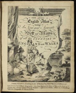
Robert Sayer No. 53, in Fleet Street, London, 1787-[c.94]
RARE EDITION. Small quarto (235 x 185 mm.), contemporary half calf, marbled paper boards, with gilt ruled bands, green calf gilt title label, light wear. With engraved pictorial title and Index, Preface and 49 engraved maps including a newly introduced folding map of England and Wales by Thomas Jefferys, all in fine early wash colour, each accompanied by a leaf of descriptive text, and a larger folding distance chart, internally in very good condition.
Stock number: 10164
£ 4,500
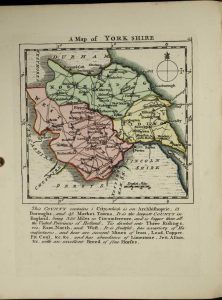
T. Carnan, in St. Paul's Church Yard, London, [1759]-[c.79]
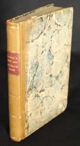
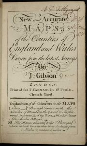
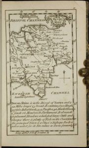
Duodecimo (130 x 80 mm.), contemporary quarter calf, rebacked preserving original marbled paper boards, spine with double gilt ruled bands, with red calf gilt title label. With engraved title and 53 numbered maps, engraved throughout, in good condition.
Stock number: 10167
£ 2,950
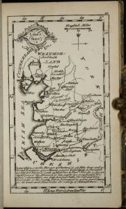
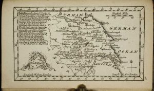
Joseph Wild, at the Elephant at Charing-Cross, London, 1701
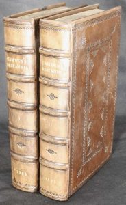
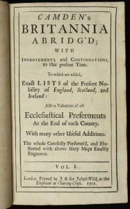
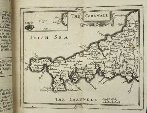
Octavo, two volumes (190 x 115 mm. each), full modern calf, ornate blind panels with corner decoration, spine with raised bands, blind ruled with ornate blind decoration, gilt titles. With typographic title pages to both volumes, pp. (26), 466, (10); frontispiece engraved portrait of William Camden by M. V. Gucht (repaired tear), (2), (paginated 467-822), (2), 103, (5), with 61 engraved maps, otherwise in good condition.
Stock number: 10132
£ 1,150
Marriott, John Grismand and Thomas Dewe, London, 1622
![[Poly-Olbion] A Chorographicall Description of All the Tracts, Rivers, Movntains, Forests, and other Parts of this Renowned Isle of Great Britain, With intermixture of the most Remarkable Stories, Antiquities … Diuided into two Bookes; the latter containing twelve Songs, neuer before Imprinted](https://www.caburdenraremaps.com/wp-content/uploads/2022/01/10136a-154x300.jpg)
![[Poly-Olbion] A Chorographicall Description of All the Tracts, Rivers, Movntains, Forests, and other Parts of this Renowned Isle of Great Britain, With intermixture of the most Remarkable Stories, Antiquities … Diuided into two Bookes; the latter containing twelve Songs, neuer before Imprinted](https://www.caburdenraremaps.com/wp-content/uploads/2022/01/10136b-210x300.jpg)
![[Poly-Olbion] A Chorographicall Description of All the Tracts, Rivers, Movntains, Forests, and other Parts of this Renowned Isle of Great Britain, With intermixture of the most Remarkable Stories, Antiquities … Diuided into two Bookes; the latter containing twelve Songs, neuer before Imprinted](https://www.caburdenraremaps.com/wp-content/uploads/2022/01/10136c-300x230.jpg)
![[Poly-Olbion] A Chorographicall Description of All the Tracts, Rivers, Movntains, Forests, and other Parts of this Renowned Isle of Great Britain, With intermixture of the most Remarkable Stories, Antiquities … Diuided into two Bookes; the latter containing twelve Songs, neuer before Imprinted](https://www.caburdenraremaps.com/wp-content/uploads/2022/01/10136d-300x224.jpg)
![[Poly-Olbion] A Chorographicall Description of All the Tracts, Rivers, Movntains, Forests, and other Parts of this Renowned Isle of Great Britain, With intermixture of the most Remarkable Stories, Antiquities … Diuided into two Bookes; the latter containing twelve Songs, neuer before Imprinted](https://www.caburdenraremaps.com/wp-content/uploads/2022/01/10136e-300x215.jpg)
![[Poly-Olbion] A Chorographicall Description of All the Tracts, Rivers, Movntains, Forests, and other Parts of this Renowned Isle of Great Britain, With intermixture of the most Remarkable Stories, Antiquities … Diuided into two Bookes; the latter containing twelve Songs, neuer before Imprinted](https://www.caburdenraremaps.com/wp-content/uploads/2022/01/10136f-300x222.jpg)
THE RARE ENLARGED EDITION. ONE OF THE LONGEST POEMS IN THE ENGLISH LANGUAGE. Folio (270 x 180 mm.), two parts bound in one, full modern morocco binding by Riviere, boards with ornate gilt panelling, ribbed spine with very ornate gilt decorated compartments, gilt title, marbled endpapers, gilt-edged. Verses describing the engraved frontispiece, recto blank; engraved allegorical title (with title 'Poly-Olbion'), verso blank; typographic title page worded as above, verso blank; Dedication to Henry Prince of Wales, verses on the verso; engraved portrait of Prince Henry at lance exercises in its second state, verso blank; Address by Michael Drayton 'To the Generall Reader' [A1]; 'From the Author of The Illustrations' [John Selden] dated 9 May 1612 [A2r-A4v]; 'A Table to the Chiefest Passages, in the Illustrations ...' pp. 8; Text of the 18 songs by Drayton, each song preceded by its proper map most probably engraved by William Hole; misprint in pagination of 285 for 258 still present; with 'Finis' sometimes found between the two woodblocks at the end of the first part on p. 303; typographic title to the second part with Drayton's name present; Dedication to Charles Prince of Wales, verso blank [A1]; Drayton's Preface [A2]; Commendatory verses [A3r-4v]; text of the 12 further songs by Drayton, each song preceded by its proper map most probably again engraved by William Hole. pp. (22), 303, (1); (10), 168. The typographic frontispiece from another example, first map with lower margin loss repaired, maps 2, 3, 5, 8, 19, 24 and 26 with extended margins, 12, 17 and 27 with small loss, otherwise a good example.
Stock number: 10136
£ 6,950
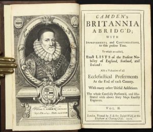
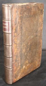
Printed by Mary Matthews, for Awnsham Churchill, and Sold by William Taylor, in Pater-Noster-Row, London, 1722
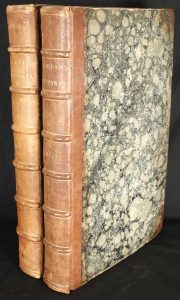
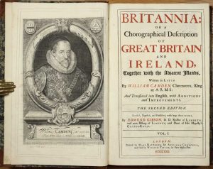
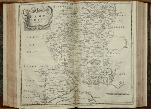
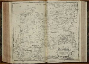
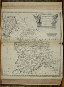
Folio, two volumes (380 x 240 mm. each), early half calf, marbled paper boards, ribbed spines, gilt ruled, gilt titles and volumes numbers, later endpapers watermarked 1804. Volume 1 with engraved portrait of Camden by R. White, typographic title printed in red and black within double ruled border to both volumes and 51 engraved maps including 3 engraved general maps, 42 double-page county maps and general maps of North and South Wales, North and South Scotland, Ireland and the Smaller Islands by Robert Morden, 9 engraved plates of coins, 4 engraved illustrations in the text, one full-page, pp. (66), cclxviii (double column numeration), (2), 696 (double column numeration); (2), 697-1526 (double column numeration), (175), Hampshire, Derby, Worcestershire and Stafford trimmed close, Surrey repaired tear lower right, Hertfordshire tight as usual, otherwise in good condition.
Stock number: 10141
£ 1,950
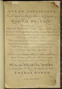
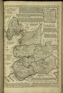
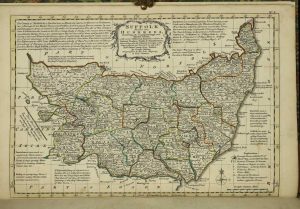
Thomas Bowles & Emanuel Bowen, London, 1720
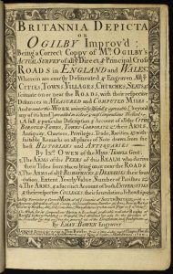
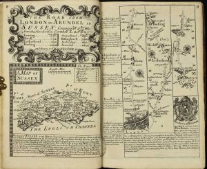
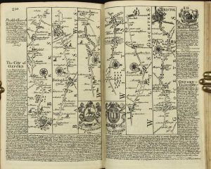
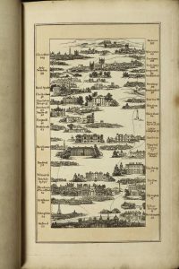
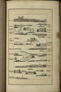
FIRST EDITION, SECOND ISSUE. Octavo (200 x 135 mm.), full contemporary calf with ornate blind and gilt panelled boards, rebacked with raised bands, each compartment blind ruled, burgundy calf gilt title, later endpapers. With title page, pp. (6), 273 engraved plates of road strips and county maps printed back-to-back, engraved throughout. Dark impressions, in good condition.
Stock number: 10144
£ 850